
Flights contracted by USDA use a three letter identifying code for the county photographed. The flight ID is the three letter county code followed by the year flown. Below is a map showing USDA county codes for California. Not all counties were given a code.
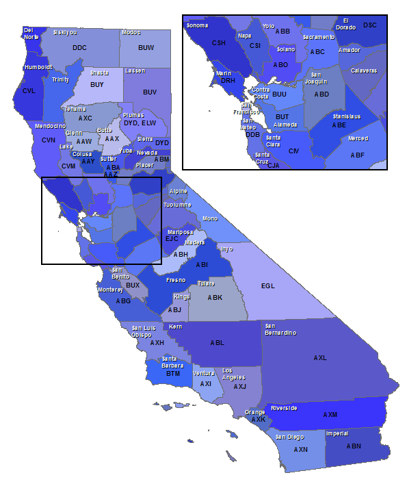
| Code | County | Code | County |
|---|---|---|---|
| AAW | Glenn | AXN | San Diego |
| AAX | Butte | BTM | Santa Barbara |
| AAY | Colusa | BUT | Alameda |
| AAZ | Sutter | BUU | Contra Costa |
| ABA | Yuba | BUV | Lassen |
| ABB | Yolo | BUW | Modoc |
| ABC | Sacramento | BUX | San Benito |
| ABD | San Joaquin | BUY | Shasta |
| ABE | Stanislaus | CIV | Santa Clara |
| ABF | Merced | CJA | Santa Cruz |
| ABH | Madera | CSH | Sonoma |
| ABI | Fresno | CSI | Napa |
| ABJ | Kings | CVL | Humboldt |
| ABK | Tulare | CVM | Lake |
| ABL | Kern | CVN | Mendocino |
| ABM | Placer | DDB | San Mateo |
| ABN | Imperial | DDC | Siskiyou |
| ABO | Solano | DRH | Marin |
| AXC | Tehama | DSC | El Dorado |
| AXH | San Luis Obispo | DYD | Plumas |
| AXI | Ventura | DYD | Sierra |
| AXJ | Los Angeles | EGL | Inyo |
| AXK | Orange | EJC | Mariposa |
| AXL | San Bernardino | ELW | Plumas |
| AXM | Riverside |
Information from: Code symbols: identification of aerial photography. Aerial Photography Division, Agricultural Stabilization and Conservation Service, United States Department of Agriculture. Washington, D.C. 1969. available in MIL Reference: TR810 .C63 1969